




AutoCAD Map 3D Toolset: CAD and GIS Mapping Software
The AutoCAD Map 3D toolset adds GIS mapping tools to AutoCAD, so you can work with CAD and GIS data in one place. It's included with every AutoCAD subscription: buy AutoCAD from Hagerman and get ongoing support from our team, with live Map 3D training available. With the Map 3D toolset, you can:
- Directly access spatial data using Feature Data Objects (FDO) technology
- Directly edit geospatial data
- Manage infrastructure systems with Enterprise Industry Models
Have Questions?
Request Info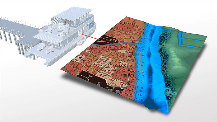

What is AutoCAD Map 3D?
AutoCAD Map 3D is one of seven specialized toolsets included with Autodesk AutoCAD. It's model-based GIS mapping software: it brings geographic information system (GIS) data into AutoCAD, so planners, engineers, and GIS teams can design and manage infrastructure using both CAD drawings and GIS data in one environment.
Map 3D is used for planning, design, and management of infrastructure such as utilities, water and wastewater networks, and municipal assets. Autodesk reports productivity gains of up to 60% on common mapping design tasks with the toolset.
AutoCAD Map 3D Features
Work With CAD and GIS Data Together
Connect to spatial data in many CAD and GIS formats and coordinate systems through Feature Data Objects (FDO), and edit geospatial data directly with standard AutoCAD commands.
Connect to Web Map Services (WMS and WFS)
Bring in background maps and live GIS features from web map services (WMS) and web feature services (WFS) through FDO connections, so your drawings sit on current, accurate base data.
Thematic Mapping
Build custom thematic maps that color and style features by their data, such as pipe size, zoning, or condition, using Map 3D's style editor and themes.
Esri ArcGIS and Enterprise Databases
Access GIS data stored in file databases or enterprise geodatabases such as Oracle, PostgreSQL, and SQL Server.
Topology and Network Analysis
Create topologies to run network calculations, for example finding which customers are downstream from a failed pump.
Enterprise Industry Models
Manage infrastructure systems such as utility networks with intelligent, industry-specific data models.

Exceptional Training and Support
Hagerman Solutions Engineers prioritize customer success with every interaction. Hagerman Training classes are developed to give you the maximum value from your technology investment, and the Hagerman support desk delivers prompt, courteous assistance when you need help.
Map 3D Training
- AutoCAD Map 3D New User (3 days)
 Course Catalog
View and register for upcoming Autodesk software training classes. All courses are virtual and taught live by Autodesk Certified Hagerman Solutions Engineers. Any course that is listed can be scheduled by request, and additional customized training courses are also available.
 Hagerman Support Desk
Hagerman & Company Support provides critical technical assistance when you need help. Our certified Support Specialists act as an extension of your technical team and will help solve your issues quickly so you can get back to business.
Buy AutoCAD to Get Map 3D
The Map 3D toolset comes with every AutoCAD subscription. See AutoCAD subscription options · Compare all seven toolsets
The following modules will only show up on dynamic pages, NOT this listing page.

Why Choose Hagerman
Hagerman & Company has built our success not only on the quality of solutions that we offer, but also on the relationships we’ve built with our clients. To do this, we have adopted a comprehensive Customer Success strategy designed to drive increased long-term customer value, improve the customer experience, and ensure customer satisfaction. This philosophy is shared across our entire organization, including sales, marketing, service delivery, and back-office support.
As a solution provider, we offer the tools to make your company more efficient, productive, and most of all, profitable. We do this by offering best-in-class software paired with professional services delivered by an exceptional team of industry consultants, solutions engineers, and support staff.

Software to Tackle Your Most Ambitious Projects
Whether you need to shorten your design cycle, improve workflows, increase productivity or bring your product to market faster - Hagerman & Company offers world class software to get the job done.
Let us know how we can help.